
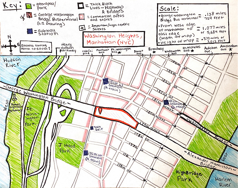
Putting the public space that I chose, the George Washington Bridge Bus Terminal, in context with the surrounding neighborhood revealed its centralized location. For instance, it is almost equidistant from its geographical borders, which are the west and east ends of Manhattan. This would make it easier for a visitor to get to since they know that whichever direction they come from, the GWB Bus Terminal will be directly in the center. Additionally, the bus terminal is located between the George Washington Bridge (which connects Manhattan and New Jersey) and the Alexander Hamilton Bridge (connecting Manhattan and the Bronx). This causes high amounts of traffic in the area, simultaneously allowing for a greater number of people to see the new bus station and know of its existence. Though not pictured, the bus terminal also has a large scaffolding design that makes it stand out from the apartment buildings surrounding it. This increases its visibility as the attention of drivers, passengers, and pedestrians in the area have their attention drawn to the bus terminal’s architecture.
Aside from these major bridges, and nearby highways, (Henry Hudson Parkway and Harlem River Drive, as shown in the map) Washington Heights is a highly commercialized area with stores on almost every corner. This is depicted in the map by the light pink shading, which I used to represent segments with a high density of stores. This specific commercial area includes clothing stores, sneaker stores, banks, convenience stores, and restaurants. Furthermore, Washington Heights is often called the “Little Dominican Republic” of New York (due to its high Dominican population and cultural influence), meaning there is a robust restaurant culture in the area that brings in a large number of visitors and interactions. This is significant in terms of the bus terminal because once again the pedestrian traffic in the area allows for more use and visibility of the bus station and its amenities.
This map relates to Kevin Lynch’s “The City and its Elements” in that the GWB Bus Terminal can be classified as a node. Lynch defines nodes as a place that visitors can enter, usually where paths meet or converge. In this case, the paths meeting are the heavy traffic streets like Broadway and Fort Washington Avenue, which border the bus terminal. Because this location is easily accessible by bus, subway, and car, there is definitely a sense of convergence when it comes to transportation. As for more of Lynch’s city elements depicted in the map- paths are seen with the transit lines (the A train and the 1 train, with 3 nearby stations) and highways. Edges, or physical boundaries can be seen with the Hudson and the Harlem River which border this part of upper Manhattan, as previously mentioned. Similarly, some of these elements depicted on the map also align with Peter Calthrope’s “Neighborhood”. This text outlines specific features that neighborhoods have, in this case, the more applicable ones being “the neighborhood has a center and an edge” and “the neighborhood gives priority to the creation of public space and to the appropriate location of civic buildings”. Taking into consideration the bus terminal and its relationship to the surrounding area, one can argue that the bus terminal is the center due to its high use and centralized location. The surrounding neighborhood also incorporates other types of public space, notably parks (Fort Washington Park, J Hood Park, and Highbridge, all pictured). As for the civic buildings, there are also some small schools, churches, concert halls that act as a site of gathering and community for the residents of Washington Heights.