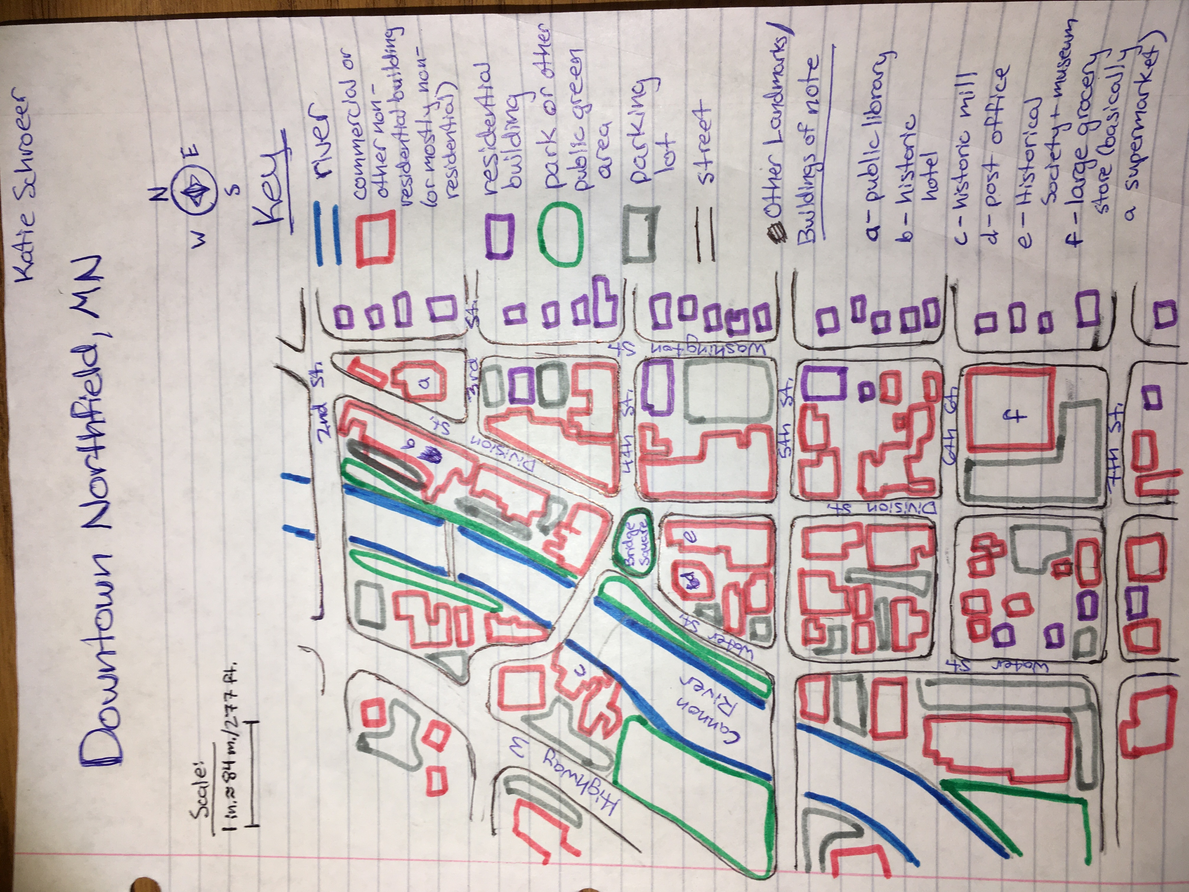
Bridge Square is in the center of downtown Northfield, at the intersection of several busy streets. Of particular note is Division Street, the “Main Street” of Northfield, along which many small businesses and local institutions lie. Downtown Northfield is the most historic part of town, with storefronts dating back over 150 years, and is still one of the main commercial centers. It is also the most recognizable image of Northfield for those who do not live here, and every tourist or visitor will see this part of town. When deciding how far to extend my map for the neighborhood context assignment, I wanted to show most of downtown, since that is the neighborhood or, in Lynch’s terms, the district that Bridge Square is in. The north edge of downtown, to me, is 2nd St., which divides the library and a block of small businesses from the property of Carleton College. The east edge is Washington St., on the other side of which lie blocks that are almost entirely residential. The west edge is Highway 3, Northfield’s biggest and busiest thoroughfare. The south edge is the least well-defined, but I end my map at 7th St., south of which the number of residential buildings on each block easily outnumber non-residential buildings. These “edges” are not perfectly clear divisions, but they can still impact how people navigate either side. For example, while there are a few buildings west of Highway 3 that might be considered by some part of “downtown,” Highway 3 is still a clear and divisive edge because its presence decreases interaction between the areas on either side of it; some parents discourage or forbid their kids from crossing the highway unsupervised and pedestrians are more likely to stay on one side of it when going out than to cross it, largely because crossing it is more loud, dangerous, and disruptive than avoiding it. The dividing line between the “east” and “west” sides of town is generally accepted to be either the river or the highway (they run very close and approximately parallel to each other), which I see as further evidence that this is an impactful and divisive edge.
Within these boundaries is the core of downtown Northfield. While in recent years there are a growing number of businesses being established at the south edge of town along Highway 3, most of what most people need in a commercial district can still be found in this area. Everything from grocery stores to fancy restaurants to pubs, all kinds of shops, a bank, a hotel, a plant nursery, hair salons - all these and more are present in this relatively small and for most, easily walkable section of Northfield. A variety of institutions and organizations such as the public library, the Historical Society, a youth center, and the Post Office are also found here. Bridge Square is in the center of all this, and I think serves as both the main node and a major landmark in the district of downtown Northfield. Many paths (the Riverwalk, Division St., Water St., etc) meet there and it is a short detour from other major paths like Highway 3, but it is not only an intersection but also a place at which people traveling those paths want to stop, whether to sit, visit a nearby shop, fish, peoplewatch, play, get some water, or participate in a festival or protest. For all these reasons, it is also a destination in and of itself, and I think its location at a well-traveled intersection and its own attractive and interesting features combine to make it a major node. Because it is such a well-known and recognizable place, it also serves as a landmark which people can use to orient themselves.
For all its centrality and recognition, though, there are still those for whom it is less accessible than for others. For example, it is more easily and safely accessible for me, living on the same side of Highway 3, than for someone who would have to cross the highway to get there - especially someone who could not drive. Even discounting the highway, the frequency of high-traffic streets might serve as a deterrent to walkers and bikers, and there are hills both in downtown and on the way there that could pose a challenge to less physically able people. Despite it being fairly geographically central, downtown is far from some of the lower-income areas of town and several senior centers - both populations that might have a higher dependence on walking or on the (near nonexistent) public transportation and therefore would have a harder time getting there in the first place.