
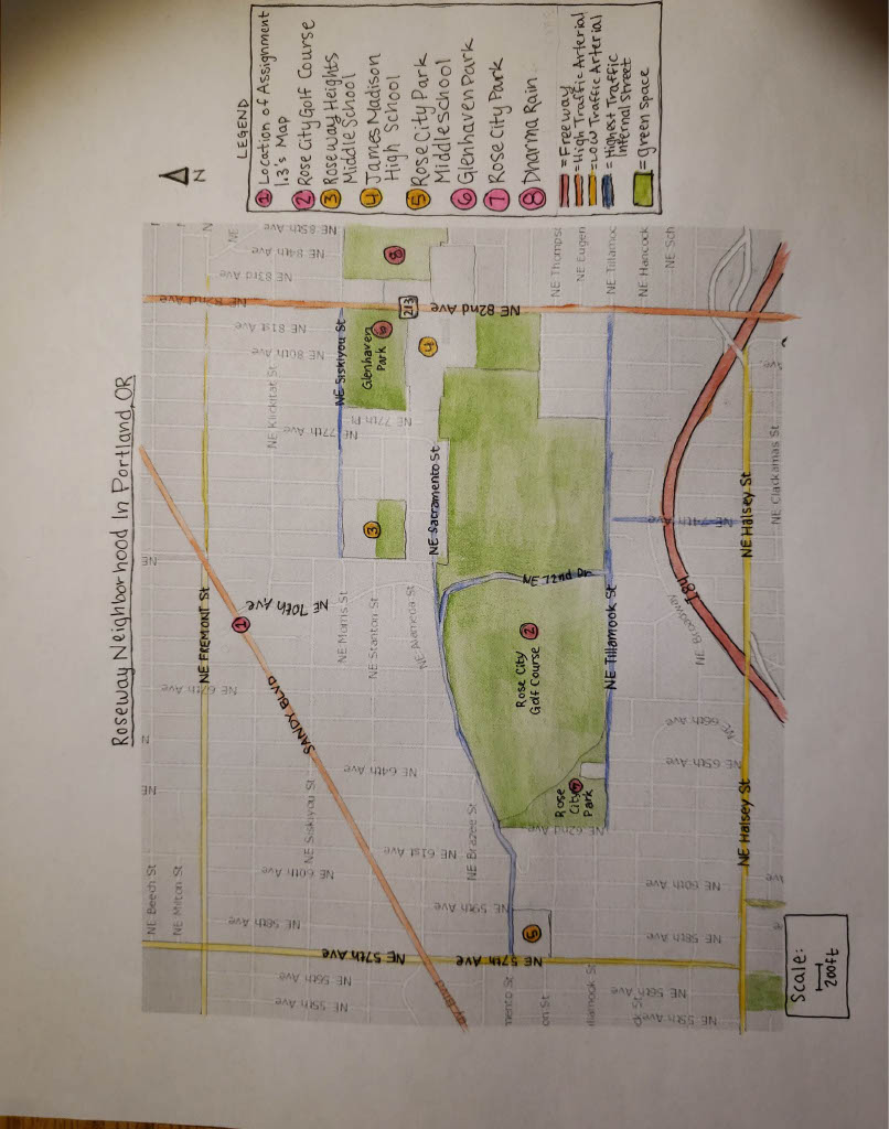
Important note: The area depicted in my map is not the legal zone of the Roseway neighborhood in Portland, Oregon, but I will be referring to it as the Roseway neighborhood because that it how residents think of it.
Two of the most influential readings we have done about urban divisions and mapping have been from Kevin Lynch and Clarence Perry. In Lynch’s paper, he poses a set of classifications for the concepts that stick out in citizen’s mental maps of spaces. He lists paths, edges, districts, nodes and landmarks as the main elements present in the city image. In this map, there are many paths. Every street can be considered a path, but some streets are more major paths than others. The most major paths would be 82nd Avenue, Sandy Boulevard, Halsey Street, 57th Avenue, and Fremont Street. I84, the freeway is more an edge than a path from the perspective of this area. There are some lesser paths within the neighborhood, like Sacramento Street, Tillamook Street, 72nd Drive, and Siskiyou Street. Those streets are more commonly used than average neighborhood streets because they are much wider than average.
The most major paths of this area also function as the edges. Sandy is a lesser dividing line between the northwest area of this neighborhood and other parts, but Fremont is the real definitive divider. Sandy is very imposing because of its size. It is four lanes (two in each direction) wide and a barrier for pedestrians and cars alike. Like Sandy, 82nd is quite a wide street, but unlike Sandy, 82nd is actually a section of Oregon Route 213. Probably because of this, 82nd is lined mostly by fast food chains, huge car-centric commercial grocery stores, strip clubs, and used car lots. The distastefulness of 82nd makes it a very strong dividing line. The other side of 82nd is seen as more of a “bad” area than Roseway, despite such a small, arbitrary dividing line.
Lynch mentions districts in his article, and since I am focusing on one district, there is not much to say about this. One thing he says is that physical characteristics are often visual cues that differentiate districts. One thing that separates the Roseway Neighborhood from the one directly to the north of it, beyond Fremont, is that in the district on the other side of Fremont, only the streets going north to south have sidewalks. The streets going east to west without sidewalks are occasionally unpaved and often poorly maintained by the city. Plus, the houses are noticeably smaller on the other side of Fremont. There are historical reasons for this difference, but today it functions as a visual differentiation between Roseway and that neighborhood.
The fourth thing Lynch brings up are nodes. These are difficult to identify at this scale. The nodes that come to mind for me are the following: The junction of 57th Avenue and Sandy Boulevard, 82nd Avenue’s overpass across I84, the intersection of Siskiyou Street and 82nd Avenue, and the intersection of Fremont, Sandy and three other neighborhood streets.
The major landmarks in this area are the many parks and the three schools: Madison High School, Roseway Heights Middle School, and Rose City Park Elementary. Rose City Golf Course is the most major landmark purely because of the massive size of it, and how it bisects the neighborhood in both directions.
Perry’s reading talked about his principles for the ideal neighborhood-unit. He proposes that the ideal size of a neighborhood is one which provides sufficient population for an elementary school. This neighborhood is located around not one, but three schools. However, the neighborhood is far from providing the entire population of the schools. As Perry believed, the social interactions of Roseway residents are indeed based around schooling, school functions and peers/fellow parents.
Roseway follows Perry’s principle that arterial streets should bound the area. Sandy, 82nd, 57th, Fremont, and Halsey all act as both major paths and boundaries for the area. Perry also believed that these arterial streets should house most of the local shops. Sandy is the most local shop-heavy street, but Fremont, Halsey and 82nd also have a few local establishments along them. Perry also believed that the internal street system should be designed to discourage through traffic. Roseway’s biggest internal street is Sacramento. Sacramento does not go through to 82nd, which severely lessens the traffic on it. Tillamook intersects with Sandy, but it does not connect gainfully on the other end. Plus, the golf course takes up so much space in the middle of the area that it is relatively complex get through from the north side to the south side. The one road through the golf course is quite unpleasant to drive on because of the steep angle at which it connects with Sacramento.
The Roseway Neighborhood has a number of open green spaces such as the parks, golf course and school fields. Most of them are centrally located, which makes them more inaccessible to other neighboring areas. Perry believed that institution sites such as these should be centrally located to more effectively serve their constituency. Similar to the green areas, one of the schools in the neighborhood I very centrally located. Roseway Heights is currently a middle school, and serves a much greater area than just the Roseway neighborhood, but when I attended, it was a K-8. A K-8 requires a much more heterogenous population of children, which requires a smaller population, so the population of the school was almost entirely made up of Roseway families. Madison high school is located on the edge of the neighborhood and has always served other neighborhoods than Roseway. In fact, as you get closer to the west side of the neighborhood, you get closer to the other high school in the area, which is Grant. Grant is a much richer school and is considered to be better than Madison, so a fair amount of students in the Roseway area, which is a relatively well-off neighborhood, choose to commute further to the better funded high school and abandon what would geographically be considered their high school.
In assignment 1.2 I chose a public space located along Sandy Boulevard, south of the large triangular block and left of the intersection of Fremont and Sandy Boulevard. On the map this spot is labelled as location 1. This space is at the edge of the neighborhood, and also adjacent to the node that is the complex intersection of Sandy and Fremont and other neighborhood streets. This location allows for patronage from the neighborhood I am focusing on, from the neighborhood north of Fremont, and from commuting drivers. As this location is on Sandy, a main commuting street, it is very easy to get to, and could be considered a node.