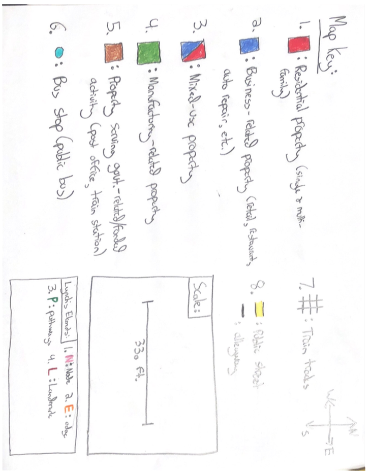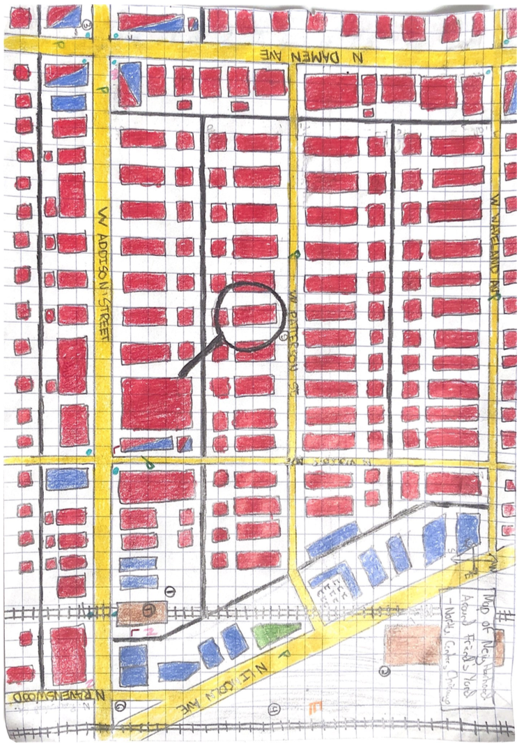
Noteworthy points on the map (marked with numbers):
The Addison Brown Line Station: One of the stations along Chicago’s “brown” elevated train line that runs through much of Northwest Chicago, this station is a major transportation hub of the surrounding neighborhood and an anchor for its vitality. Dense residential housing and businesses of many sorts surround the station, and bus lines have a designated stop immediately in front of the entrance, making the stretch of Addison Street over which the station exists a constant source of movement and traffic. Because of its prominence within the neighborhood and junction of pathways, the Addison stop is both a Node and a Landmark.
U.S Post Office Carrier Annex: One might never glance twice at this large building taking up a majority of the property on the east side of Lincoln Ave. between Addison St. and Waveland Ave. One of the USPS’ carrier annexes, residents will use this location to drop off packages or complain about their service. The facade is nothing to be desired -- brown, grimy brick with a wraparound black tile pattern and a plain black eagle above the doorway facing a parking lot that is almost always half-empty. However, the building makes itself noticeable to passerby, as its flat, horizontal design breaks up the pattern of densely-packed storefronts that line N. Lincoln Ave. on other parts of the street.
Intersection of N. Damen Ave. & W. Addison St.: Both prominent streets on Chicago’s North Side, the intersection of these two avenues almost never sleeps. West Addison Street serves as an important corridor for cars, cyclists, and buses to traverse the North Side, as the avenue is one of the few streets to cross the Chicago River (just one mile west of the intersection), and the famous Wrigley Field (home of the Chicago Cubs) lies just a few blocks to the east. During a given summer day, Cubs fans can be seen traveling east via sidewalk, bus, or car, while factory trucks share the roadway with other vehicles traveling west (many factories are near the river on other parts of the North Side). Damen Avenue is also a key corridor, as the street is one of the few with a designated bike lane. Along both streets, one can find a number of businesses, dense development projects, and bus stops. The collision of these two streets, therefore, is a constant source of activity. Buses unload and depart during all points of the day at the intersection’s four different stops, sharing the road with cyclists, automobiles, and trucks. Families, groups of friends, and other individuals from the surrounding area utilize the sidewalk to access neighborhood resources in close proximity or as a way to traverse to other areas of the neighborhood. Each corner of the intersection is home to a different mixed-use retail space, attracting passerby. And, looming over the entire space is a grand, intricately-designed turret hanging off a mixed-use apartment/retail building on the southeast corner. I classify this intersection as a Node, and both Addison and Damen as Paths.
The Ravenswood Train Tracks: These train tracks, slightly east of the CTA-used tracks, serve as an important barrier on the North Side. Used to transport goods made by the factories along the Ravenswood Avenue industrial corridor (which runs adjacent), today, these tracks are also used by the Metra train line. These tracks differentiate from the CTA’s elevated tracks due to the fact that they’re much lower to the ground (though slightly elevated above the street level), and act much more of a barrier due to the limited number of underpasses. Surrounding the tracks on both sides are thick walls of stone and fence. Therefore, because of its power, many see the tracks as the border between many North Side neighborhoods -- in this case between Roscoe Village (the name of the neighborhood of which I’ve drawn a portion) and Lakeview. I therefore classify these tracks as an Edge.
My Friend Ian’s House and Backyard: Under the magnifying glass is my friend Ian’s house. I just wanted to point that out.
Intersection of W. Addison St., N. Ravenswood Ave., & N. Lincoln Ave.: Though certainly not the most eye-appealing location in the neighborhood, this intersection serves as a key local access point. Lincoln Avenue is a diagonal street which connects much of the North Side. It serves as an important corridor for cyclists, automobiles, and trucks. This intersection is of importance due to the fact that it is one of the key entrances to the neighborhood for those on Lincoln Avenue, as it is one of the few spots in Roscoe Village where two main streets intersect. I designate this spot as a Node.
Jared Saef
Urban Culture and Society
1.3: Roscoe Village in Context
In order to best illustrate the neighborhood surrounding my friend Ian’s backyard without losing detail, I chose to map the areas of commerce and residence in a roughly two-block radius from the house itself. I put much time into figuring out the best scale to use and ultimately decided to concentrate to the most local level to help viewers understand how Ian and his family interact with and understand the city through the community immediately around them.
For context, Ian lives in the 1900 block of West Patterson Avenue in a North Side neighborhood known as Roscoe Village, a once-industrial community that retained its factory-esque feel and old, brick housing stock even through its process of rapid gentrification in the mid-1990s. Today, Roscoe Village is home to mostly middle-class/upper middle-class White families and couples, and the neighborhood’s several retail corridors -- bookstores, trendy restaurants, gift stores -- cater to its community members’ priorities and desires. Most of the neighborhood’s residential streets are lined with lush trees and old, rehabbed housing stock built of brick and limestone, and the sound of roaring trains can be heard in the near distance from almost any spot in the area, as the neighborhood is very close in proximity to many stops along the CTA’s brown line. Roscoe Village also boasts a number of independent stores and restaurants supported by the community, and a strong neighborhood group that frequently organize events and field resident requests.
After mapping out the area immediately around Ian’s house, I came to clearly understand how he interacts with the neighborhood through the nodes and landmarks that surround him, how he accesses other parts of the city through the paths, and how he may feel constrained by the neighborhood edges.
Nodes:
On my map, I pointed out several nodes that I have seen Ian utilize:
Intersections of Addison/Damen (3), and Addison/Ravenswood/Lincoln (6): On several occasions, I have agreed to meet Ian at both of these intersections due to their convenient proximity to bus and train lines and the many restaurants that surround them. When at these locations, I have also noted how they are both popular areas for others in the neighborhood to interact.
The Addison train stop: Last March, when I asked Ian’s parents why they chose to live in Roscoe Village, the first reason that they brought up was the neighborhood’s proximity to Mass Rapid Transit. Because Ian lives just two blocks from the stop, he frequently uses the train to travel to other areas of the city. Additionally, as noted above, the Addison stop is a prominent place in the neighborhood because of the bus lines that intersect with it and the businesses that surround it.
Paths:
I have also noted several Paths that Ian frequently uses, and here I will discuss the two most important ones:
N. Lincoln Ave:. Every morning and afternoon, Ian’s mom drove him and his sister via Lincoln Ave. to our high school. This street was most convenient for them due to its proximity to their house and the avenue’s proximity to the school itself. Additionally, over the summer, when I went to Ian’s house, I’d most frequently use Lincoln Avenue to do so.
W. Addison St.: Ian and his family are avid Cubs fans, and to attend games, they often would walk to Wrigley Field by walking along Addison Street. They claim that they enjoy doing this most because of the herd of Cubs fans that also happen to walk with them -- they say they feel more part of the crowd and excitement this way. Additionally, because Addison Street is one of the North Side’s larger and continuous streets, Ian and I have used it (both by car and foot) to access nearby retail corridors in other neighborhoods.
Landmarks:
The Mushroom House: Looking closely at the map, one may be able to observe that I marked an “L” near the mixed-use property on the northeast corner of Wolcott/Addison. Lying at this corner is a building designed so obscurely that it is almost impossible to miss. The first floor is covered in a thick layer of white stucco, with circular windows of varying sizes popping out at various areas of the facade. The second floor is covered entirely in dark wood roofing, its size at least two times larger than the first floor. Thus, the building has the appearance of a mushroom, and Ian and I quickly came to give it the above nickname. Thus, we began naturally using it among our friend group as a meeting point before boarding the train at the Addison stop just down the block due to its inarguable uniqueness.
The Addison train stop: Because this train stop is such a focal point of the area immediately surrounding Ian’s block, I have seen the way in which Ian and his family use it as a sort of point of orientation, and I have also used it in the same way when I am with them. For example, I distinctly remember being at Ian’s house one night of my freshman year when we were searching online for a restaurant at which to eat for dinner. When Ian’s mom approached us and told us about a Thai place that was just “three steps from the Addison stop,” we already knew the route to get there.
Edges:
The only edge I have marked on the map is the Ravenswood train tracks, as mentioned above. For many in Roscoe Village, those train tracks are seen as a formal border between their area and the adjacent community of Lakeview.